Use Cases
A FlowFieldOverlay is added to overlay vector data onto the base map to visualize dynamic flow information, such as wind fields and ocean currents. It is applicable to scenarios where the fluid motion status needs to be displayed in real time.
Starting from 6.0.0(20), the FlowFieldOverlay function is supported.
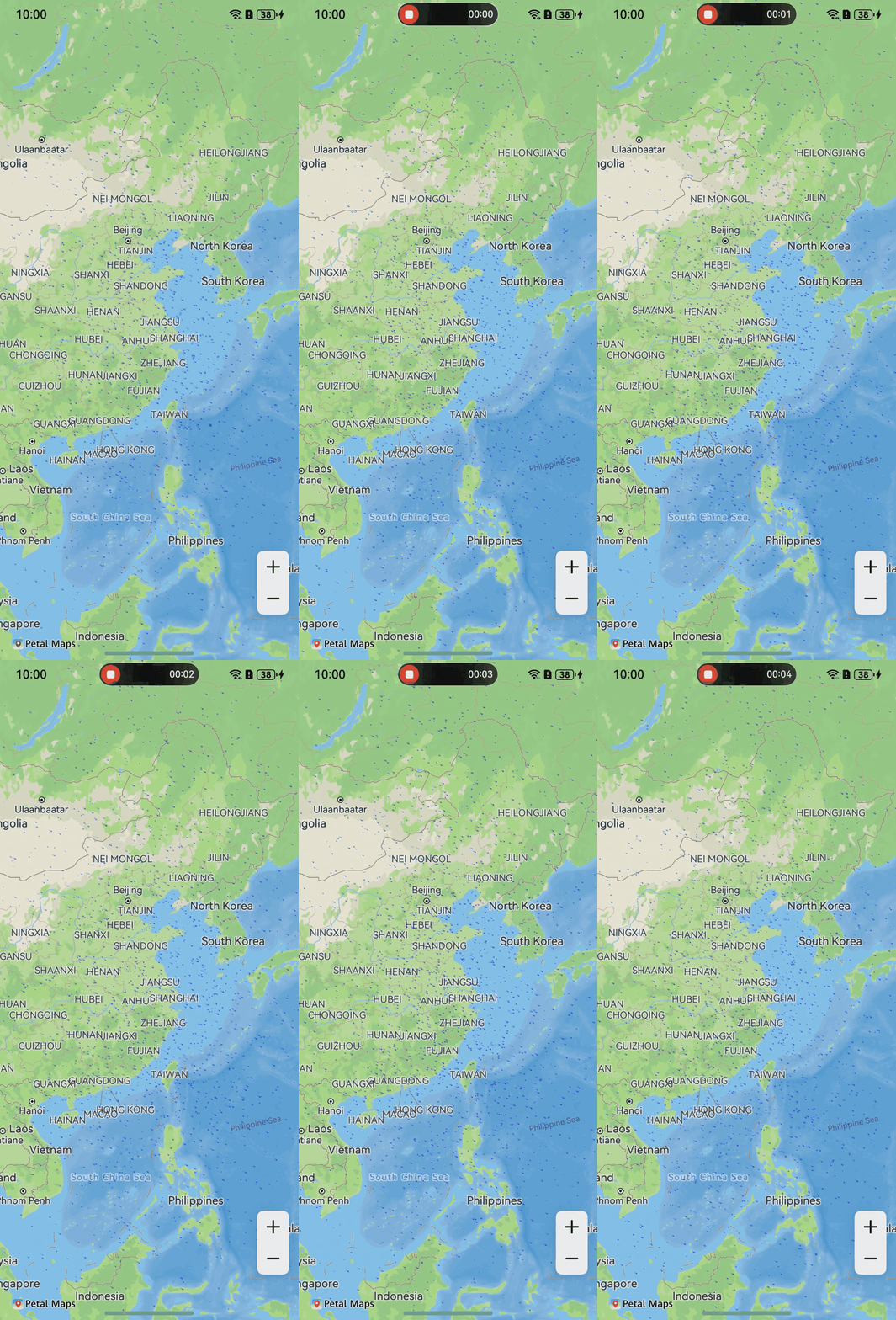
API Description
The FlowFieldOverlay functions are mainly provided by FlowFieldOverlayParams, addFlowFieldOverlay, and FlowFieldOverlay. For more information about the APIs, please refer to API Reference.
| API | Description |
|---|---|
| FlowFieldOverlayParams | FlowFieldOverlay parameters. |
| addFlowFieldOverlay(params: mapCommon.FlowFieldOverlayParams): Promise<FlowFieldOverlay> | Adds a FlowFieldOverlay. |
| FlowFieldOverlay | FlowFieldOverlay object. |
[h2]Adding a FlowFieldOverlay
-
Import required modules.
import { mapCommon, map, MapComponent } from '@kit.MapKit'; import { AsyncCallback } from '@kit.BasicServicesKit'; -
Draw a FlowFieldOverlay.
@Entry
@Component
struct MapFlowFieldOverlayDemo {
  private TAG = "OHMapSDK_MapFlowFieldOverlayDemo";
  private mapOption?: mapCommon.MapOptions;
  private mapController?: map.MapComponentController;
  private callback?: AsyncCallback<map.MapComponentController>;
  private fieldOverlay?: map.FlowFieldOverlay;

  aboutToAppear(): void {
    this.mapOption = {
      position: {
        target: {
          latitude: 31.984410259206815,
          longitude: 118.76625379397866
        },
        zoom: 4
      },
      scaleControlsEnabled: true
    }

    this.callback = async (err, mapController) => {
      if (!err) {
        this.mapController = mapController;
        let params: mapCommon.FlowFieldOverlayParams = {
          // The value of data must be in JSON format and complies with the GRIB2 specification. Set data by referring to flow field data format.
          data:
          `[{
            "header": {
              "parameterUnit": "m.s-1",
              "parameterNumber": 2,
              "dx": 10,
              "dy": 20,
              "parameterNumberName": "U-component-wind",
              "la2": -90,
              "la1": 90,
              "parameterCategory": 2,
              "lo1": 0,
              "lo2": 359.75,
              "ny": 4,
              "nx": 4,
              "numberPoints": 16
            },
            "data": [2, 2, 2, 2, 2, 2, 2, 2, -10, -10, -1, -1, -1, -1, -3, 2]
          }, {
            "header": {
              "parameterUnit": "m.s-1",
              "parameterNumber": 3,
              "dx": 4,
              "dy": 4,
              "parameterNumberName": "U-component-wind",
              "la2": -90,
              "la1": 90,
              "parameterCategory": 2,
              "lo1": 0,
              "lo2": 359.75,
              "ny": 4,
              "nx": 4,
              "numberPoints": 16
            },
            "data": [1, 1, 1, 1, 1, 1, 1, 1, 1, 1, 1, -1, -1, -2, -3, -1]
          }]`,
          style: {
            count: 2000,
            color: 0xff0000ff,
            maxSpeed: 100,
            speedFactor: 1
          }
        };

        try {
          // Add a FlowFieldOverlay.
          this.fieldOverlay = await this.mapController?.addFlowFieldOverlay(params);
        } catch (e) {
          console.error(this.TAG, `code:${e.code}, message:${e.message}`);
        }
      } else {
        console.error(`Failed to initialize the map. Code: ${err.code}; message: ${err.message}`);
      }
    }
  }

  build() {
    Stack() {
      Column() {
        MapComponent({ mapOptions: this.mapOption, mapCallback: this.callback })
          .width('100%')
          .height('100%');
      }.width('100%')
    }.height('100%')
  }
}
[h2]Flow Field Data Format Reference
The value of data in the FlowFieldOverlayParams class is in JSON format and complies with the GRIB2 specification. GRIB2 is a binary data format defined by the World Meteorological Organization (WMO), primarily used for storing and transmitting meteorological and climate data.
[
  // header indicates the overall information of data, and data indicates the zonal velocity.
  {"header":{},"data":[]},
  // header indicates the overall information of data, and data indicates the meridional velocity.
  {"header":{},"data":[]}
]
The following is an example of wind field data:
[{
  "header": {
    "parameterUnit": "m.s-1",   // Wind speed unit.
    "parameterNumber": 2,       // Wind direction. The value 2 indicates the U-component (zonal), and the value 3 indicates the V-component (meridional).
    "dx": 10,                   // Zonal spacing, that is, the longitude value occupied by each grid cell. The value is an integer.
    "dy": 20,                   // Meridional spacing, that is, the latitude value occupied by each grid cell. The value is an integer.
    "parameterNumberName": "U-component-wind",   // Name for the U-component of the wind.
    "la2": -90,                 // Latitude range start value. The value of la2 must be less than that of la1.
    "la1": 90,                  // Latitude range end value. The value of la2 must be less than that of la1.
    "parameterCategory": 2,     // Data category.
    "lo1": 0,                   // Longitude range start value. The value of lo1 must be less than that of lo2.
    "lo2": 359.75,              // Longitude range end value. The value of lo1 must be less than that of lo2.
    "nx": 4,                    // Number of zonal grid cells. The value is an integer.
    "ny": 4,                    // Number of meridional grid cells. The value is an integer.
    "numberPoints": 16          // Number of wind speed data points, that is, the number of data records in data.
  },
  // Zonal velocity. The number of data records must be equal to the value of numberPoints.
  "data": [2, 2, 2, 2, 2, 2, 2, 2, -10, -10, -1, -1, -1, -1, -3, 2]
}, {
  "header": {
    "parameterUnit": "m.s-1",   // Wind speed unit.
    "parameterNumber": 3,       // Wind direction. The value 2 indicates the U-component (zonal), and the value 3 indicates the V-component (meridional).
    "dx": 4,                    // Zonal spacing, that is, the longitude value occupied by each grid cell. The value is an integer.
    "dy": 4,                    // Meridional spacing, that is, the latitude value occupied by each grid cell. The value is an integer.
    "parameterNumberName": "V-component-wind",   // Name for the V-component of the wind.
    "la2": -90,                 // Latitude range start value. The value of la2 must be less than that of la1.
    "la1": 90,                  // Latitude range end value. The value of la2 must be less than that of la1.
    "parameterCategory": 2,     // Data category.
    "lo1": 0,                   // Longitude range start value. The value of lo1 must be less than that of lo2.
    "lo2": 359.75,              // Longitude range end value. The value of lo1 must be less than that of lo2.
    "nx": 4,                    // Number of zonal grid cells. The value is an integer.
    "ny": 4,                    // Number of meridional grid cells. The value is an integer.
    "numberPoints": 16          // Number of wind speed data points, that is, the number of data records in data.
  },
  // Meridional velocity. The number of data records must be equal to the value of numberPoints.
  "data": [1, 1, 1, 1, 1, 1, 1, 1, 1, 1, 1, -1, -1, -2, -3, -1]
}]